You are hereFlight Planning / Aerial tours / The Anza-Borrego Desert State Park Sky Trail
The Anza-Borrego Desert State Park Sky Trail

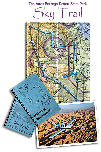
The file abskytrail.txt contains the 15 recommended waypoints to follow the Anza-Borrego Desert State Park Sky Trail described in Pilot Getaways magazine.
For a description and map of the tour, see the sidebar on page 39 of the September/October 2006 issue. The Sky Trail was developed to give pilots and their passengers a chance to enjoy the natural and historic features of the Anza-Borrego Desert State Park, some of which can only be seen from the air. The guide books were written by former state park pilot Jon Meunch and are available at the State Park Visitor Center store for $4, (760) 767-4961.
GPS waypoints make your navigation a lot easier. You can download the waypoints as a text file, or you can enter them manually from the table below.
Download GPS waypoints:
The route in Tab Delimited Text format and the Readme text file.
(Note: Clicking on the above links will bring up the text document automatically. Windows users can right-mouse-click on the links and select "Save Target As" or"Save Link As" to download the file. Macintosh users can click and hold until another menu pops up, giving you the option to download.)
The Waypoints and Coordinates:
If you cannot upload coordinates into your GPS and need to do so manually, the waypoints are listed below:
| ID |
LatD |
LatM |
N/S |
LonD |
LonM |
E/W |
|
ABST01 |
33 |
16.71 |
N |
116 |
5.74 |
W |
|
ABST02 |
33 |
0.73 |
N |
116 |
6.90 |
W |
|
ABST03 |
32 |
58.55 |
N |
116 |
11.68 |
W |
|
ABST04 |
33 |
0.28 |
N |
116 |
4.45 |
W |
|
ABST05 |
32 |
55.82 |
N |
116 |
3.39 |
W |
|
ABST06 |
32 |
45.64 |
N |
116 |
3.20 |
W |
|
ABST07 |
32 |
50.69 |
N |
116 |
9.74 |
W |
|
ABST08 |
32 |
52.95 |
N |
116 |
12.39 |
W |
|
ABST09 |
32 |
56.58 |
N |
116 |
18.42 |
W |
|
ABST10 |
32 |
59.39 |
N |
116 |
25.68 |
W |
|
ABST11 |
33 |
5.79 |
N |
116 |
28.59 |
W |
|
ABST12 |
33 |
19.29 |
N |
116 |
34.00 |
W |
|
ABST13 |
33 |
27.43 |
N |
116 |
35.47 |
W |
|
ABST14 |
33 |
23.79 |
N |
116 |
25.44 |
W |
|
ABST15 |
33 |
24.68 |
N |
116 |
20.86 |
W |
Meanings of columns in the above table:
ID: Six-character waypoint ID.
Name: Name of the waypoint.
LatD: Whole degrees of latitude of the waypoint.
LatM: Minutes and tenths of minutes of latitude of the waypoint (e.g. "42.3").
N/S: Always "N" to signify north latitude (required by some GPS programs).
LonD: Whole degrees of longitude of the waypoint.
LonM: Minutes and tenths of minutes of longitude of the waypoint (e.g. "25.3").
E/W: Always "W" to signify west longitude (required by some GPS programs).

