

You are hereFlight Planning / Aerial tours / An Aerial Tour of Los Angeles
An Aerial Tour of Los Angeles
GPS Waypoints
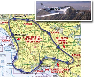
An aerial tour of the Los Angeles basin is presented in the Long Beach article of our Fall 2000 issue. This tour is a great way to see the sights of Los Angeles, but it is in some of the busiest air traffic areas in the country and comes close to Class B airspace. You should be able to hold altitude within 200 feet and not mistake one freeway for another. Take an instructor along if you are not comfortable navigating in dense urban areas. Please read the sidebar on page 8 of the Fall issue for more details on flying the tour.
NOTE: These waypoints were current as of Fall 2000, when this article was published. Since then, a TFR has been established around Disneyland prohibiting flight within a radius of 3 nm, 3000 ft. AGL and below (about 3,200 ft. MSL). It is still possible to fly the route, but you need to climb to 3,500 ft. or higher over Disneyland and contact SoCal Approach for a Class C clearance on 121.3 MHz.
GPS waypoints make your navigation a little bit easier. You can download the route as a text file, or you can enter them manually from the table below.
Download GPS waypoints:
The route inTab Delimited Text format and the Readme text file.
(Note: Clicking on the above links will bring up the text document automatically. Windows users can right-mouse-click on the links and select "Save Target As" or"Save Link As" to download the file. Macintosh users can click and hold until another menu pops up, giving you the option to download.)
The Waypoints and Coordinates:
If you cannot upload coordinates into your GPS and need to do so manually, the waypoints are listed below:
|
ID |
Name |
LatD |
LatM |
N/S |
LonD |
LonM |
E/W |
RecomAlt |
|
KLGB |
Long Beach Airport |
33 |
49.1 |
N |
118 |
9.1 |
W |
57 |
|
1AQMY |
Abeam Queen Mary |
33 |
46 |
N |
118 |
12.3 |
W |
2500 |
|
1PFMN |
Point Fermin |
33 |
42.3 |
N |
118 |
17.5 |
W |
2500 |
|
1PVNC |
Point Vincente |
33 |
44.6 |
N |
118 |
24.7 |
W |
2500 |
|
1SFRS |
SFRA - Southern Boundary |
33 |
54 |
N |
118 |
21.95 |
W |
4500 |
|
1SFRN |
SFRA - Northern Boundary |
33 |
58.2 |
N |
118 |
25.3 |
W |
4500 |
|
1AGMS |
Abeam Getty Museum |
34 |
5.7 |
N |
118 |
28.5 |
W |
2850 |
|
1AGOB |
Abeam Hollywood Sign/Griffith Observatory |
34 |
6.3 |
N |
118 |
18 |
W |
2250 |
|
1ADNT |
Abeam Downtown |
34 |
3 |
N |
118 |
14 |
W |
2250 |
|
1AI5 |
Abeam I-5 |
34 |
0.7 |
N |
118 |
7 |
W |
1750 |
|
15605 |
Abeam I-5/I-605 Interchange |
33 |
57.7 |
N |
118 |
5 |
W |
1750 |
|
1AFUL |
Abeam Fullerton |
33 |
52 |
N |
117 |
59.5 |
W |
1750 |
|
1DISN |
Disneyland |
33 |
48.7 |
N |
117 |
55.1 |
W |
1750 |
|
1ASLI |
Abeam Los Alamitos Airport |
33 |
49 |
N |
118 |
3 |
W |
1000 |
Meanings of columns in the above table:
ID: Four or five-character waypoint ID. Note that all user waypoints start with "1" so that they appear together on an alphabetical listing of waypoints.
Name: Name of the waypoint. Many waypoint names start with the word, "abeam," such as "Abeam Hollywood Sign/Griffith Observatory." In this case, the coordinates shown are those of the flight path and may be one or two miles from the actual landmark.
LatD: Whole degrees of latitude of the waypoint.
LatM: Minutes and tenths of minutes of latitude of the waypoint (e.g. "42.3").
N/S: Always "N" to signify north latitude (required by some GPS programs).
LonD: Whole degrees of longitude of the waypoint.
LonM: Minutes and tenths of minutes of longitude of the waypoint (e.g. "25.3").
E/W: Always "W" to signify west longitude (required by some GPS programs).
RecomAlt: Recommended altitude at the waypoint on the LA Basin Tour.