

You are hereDon't Be in a Fog
Don't Be in a Fog
Dealing with Nature’s Veiled Hazard
by Dale Wilson
One advantage of flying in pleasant climates is the prevalence of good VFR flying weather. However, with winter upon us, the very conditions responsible for “severe clear” weather also produce a phenomenon that poses a significant risk to flight operations: radiation fog. This type of fog, often called ground fog, spreads over wide areas and can restrict visibility to the point where even IFR flight is impossible. I remember a commercial pilot candidate who returned to his home airport after completing a VFR night cross-country flight only to find it closed due to fog. He flew back to the airport he had just come from and found that it had also closed because of fog. He really panicked after finding the same conditions at a third airport. Luckily, he was able to land at the nearby international airport before it, too, was “socked-in.”
Radiation fog forms when moist air is cooled by contact with the cold ground below. When the temperature drops to the dew point (or higher if sufficient condensation nuclei are present) then condensation occurs, creating fog. METARs and TAFs actually define a cloud resting on the earth’s surface as fog (FG) when the visibility is less than 5/8 statute mile (sm), or 1,000 meters, and as mist (BR) when the visibility is between 5/8 sm and 6 sm.
 |
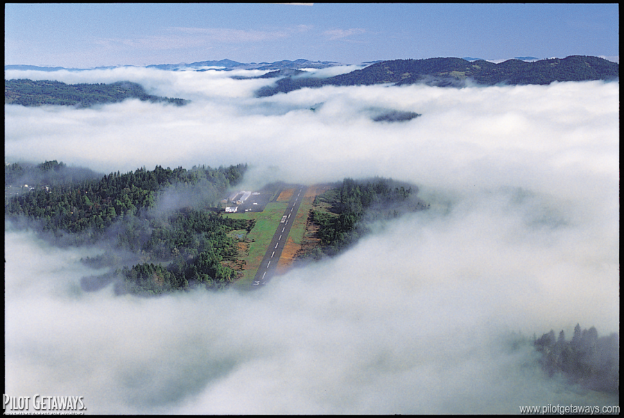
| Flying overhead, it is easy to see vertically through fog, but once you descend, horizontal visibility can be insufficient for landing. |
We’ve all been told radiation fog forms over land on clear nights, with little or no wind. It only forms over land since lakes and oceans cool significantly slower at night than soil. Clear skies enable the ground’s heat to keep radiating out into space. It should be noted that the longer nights of late fall and winter enable more heat to dissipate, causing even further cooling. Since a strong wind effectively blows the fog away by mixing moist surface air with drier air above, radiation fog forms when there is little or no wind. The thickest fog forms in the presence of a 3- to 5-knot wind; the wind’s light turbulence brings more air in contact with the cooling ground, spreading the thickness of the fog upwards.
You might also have heard that ground fog dissipates as soon as the sun rises. It isn’t true; in fact, it often gets worse. The initial heating of the surface just after sunrise can create the same effect as a light wind, causing existing fog to thicken or new fog to develop. The presence of snow only exacerbates the problem by increasing the moisture content of the air.
I once overheard the following exchange after a pilot requested a clearance to land at a Class D airport.
Tower: “Cessna 123, the airport is closed to VFR traffic, visibility one half mile in fog.”
Cessna: “But I can see the airport! Request clearance to proceed inbound.” Tower: “Negative. Tower visibility is one half mile in fog.”
Cessna: “But I’m over the airport at 3,000 feet and I can see everything just fine! Are you sure your weather information is correct?”
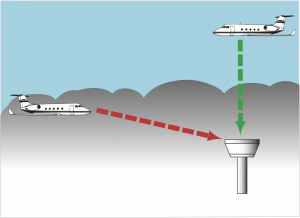
This pilot had fallen victim to a common trap. Even though the vertical and slant visibility looked fine, the horizontal surface visibility was below special VFR minima. Had the pilot attempted the approach, he would have found himself in IFR conditions. Although this may be hard to believe, imagine the following scenario: If the visibility is 300 ft. and the fog layer is only 100 ft. thick, a pilot flying overhead can see the airport, since he’s only looking vertically through 100 ft. of fog. However, once he descends to land, he needs to look horizontally through the fog, and it is impossible to land with 300-ft. visibility.
To avoid an encounter with radiation fog, always check the weather forecast beforehand. Avoid flight during the period when fog is forecast, and have a suitable alternate in mind should it develop earlier than predicted. Listen to ATIS, AWOS, or ASOS reports to determine how fast the temperature is dropping and what the temperature-to-dew point spread is. Expect fog to form when the spread narrows to within 3o C. The commercial student mentioned above who almost got trapped without a place to land admitted that he neither checked the forecast nor monitored automated weather frequencies while en route.
If the temperature-to-dew point spread is small over a large area, widespread fog can quickly engulf any alternate for many miles. I know of one pilot who couldn’t out-fly a developing fog bank to his destination. He was flying westbound, and the fog was forming as quickly as the sun was setting. What he didn’t realize is that since the temperature drops after the sun sets, he was inadvertently trying to outrun the sunset, which advances at about 700 knots at U.S. latitudes. Fortunately, he had a lot of fuel on board.
If you’re just practicing in the pattern, use your landing lights on final. If fog is beginning to develop, the light will illuminate it, signaling that you should land before it’s too late. Of course, if you find yourself engulfed in a sea of white during your flare, then you know it’s too late. You will need to successfully conduct a go-around and head to that alternate airport.
A recent AOPA study found that 16% of GA weather-related accidents occur in fog, with the majority of them involving fatalities. Don’t be a statistic; don’t be in a fog!
Dale Wilson teaches aviation weather and safety courses in the Flight Technology program at Central Washington University in Ellensburg, Washington.